
Our Mission
Obsidian 3D brings state-of-the-art 3D scanning technology to Central and East Oregon, transforming the physical world into precise digital deliverables. We are proud to be the first and only dedicated 3D capture, scan-to-BIM, and point cloud data analysis provider East of the Cascade Mountains, serving our beautiful, diverse, and rapidly growing region. Our foundation is built on 25 years of specialized capital project management expertise, spearheaded by founder Parker B. Stockdale. As a USCG Master Mariner and a leader in complex commercial and maritime construction and restoration work worldwide, Parker has led projects from concept to commissioning for some of the world’s most discerning clients with unparalleled precision. On the recommendation of his older brother, Parker moved to Bend in 2020. He worked as a project manager and superintendent in the residential and commercial construction field with a handful of well-established general contractors. In 2023 he pivoted to providing remote support for marine engineering projects across the United States through 2025, when he founded “Obsidian 3D.” Parker has worked with 3D scanning technology since 2010 and has successfully deployed it across multiple projects providing priceless, high accuracy data to build teams and clients around the world. Trained and certified by Leica Geosystems, Parker is tapped into the unbridled opportunities only possible through 3D design, inspection, documentation, and manufacturing techniques. In his downtime Parker loves spending time with his young son enjoying all the outdoors’ has to offer in Central Oregon. He’s a trained private pilot in multi-engine land and turbine helicopters and still enjoys getting out the water as often as possible. He’s been actively involved in volunteering efforts in the area since 2020 and is always looking for new ways to lend a hand to others and leave our world a better place than he found it.


For qualifying non-profit organizations and community projects, Obsidian 3D is open to discussing pro bono or significantly reduced-cost geospatial mapping services. We aim to contribute to initiatives that benefit our local community and preserve its unique heritage. We encourage non-profits to inquire about how our services might assist with their impactful work.
Community Commitment

We are eager to collaborate with educational institutions across Central and East Oregon to integrate state-of-the-art 3D scanning equipment and point cloud processing into their course curricula. This offers students invaluable hands-on experience with cutting-edge reality capture technology, preparing them for future careers. Please reach out to us if you’re interested!
Educational Outreach
About the Founder
Obsidian 3D LLC was founded by Parker B. Stockdale, drawing on his 25 years of specialized capital project management coupled with extensive private, commercial, and government clientele expertise. For the past five years, Parker has called Central Oregon home, gaining valuable experience in residential and commercial construction project management, as well as remote maritime engineering management within the region. As a USCG 3000GT Master of Oceans, he has led complex commercial and superyacht construction projects across the United States and Europe, overseeing $130M+ in managed funds, and achieving an International Superyacht Society "Refit of the Year" award while working in The Netherlands.
This extensive background has instilled a profound understanding of quality, precision, efficiency, and collaborative project execution. Our mission is to empower Central and East Oregon's architects, engineers, designers, fabricators, artists, and local government to do their most creative, efficient, and cost-effective work, by providing state-of-the-art 3D capture and modeling services. Beyond 3D capture, Obsidian 3D strives to connect the region with the fascinating and ever-expanding world of 3D modeling and design possibilities.
What truly sets Obsidian 3D apart as the first and only dedicated geospatial 3D mapping and point cloud services company east of the Cascade Mountains, serving Central and East Oregon, is our unwavering commitment to high accuracy and the immense gains our technology delivers over antiquated methods. Traditional measurement techniques often lead to costly rework, project delays, and limited detail. In contrast, our state-of-the-art 3D scanning provides precise, actionable digital twins that drastically minimize surprises and clashes, potentially saving tens of thousands of dollars in rework and preventing weeks of schedule delays.
We accelerate your design and planning phases; for example, scanning a 10,000 sq ft existing building for renovation can be completed in a single day with precise data, a process that could take multiple weeks with traditional surveys while providing less granular detail. Furthermore, our accurate 3D models (BIM-ready, CAD-ready) enhance collaboration and communication, making design review meetings significantly more efficient and identifying hundreds of potential conflicts in the design phase, each of which could cost $1,000 - $10,000+ to fix during construction. By choosing Obsidian 3D, you're not just getting data; you're gaining a foundational toolset for smarter, faster, and more profitable project execution.
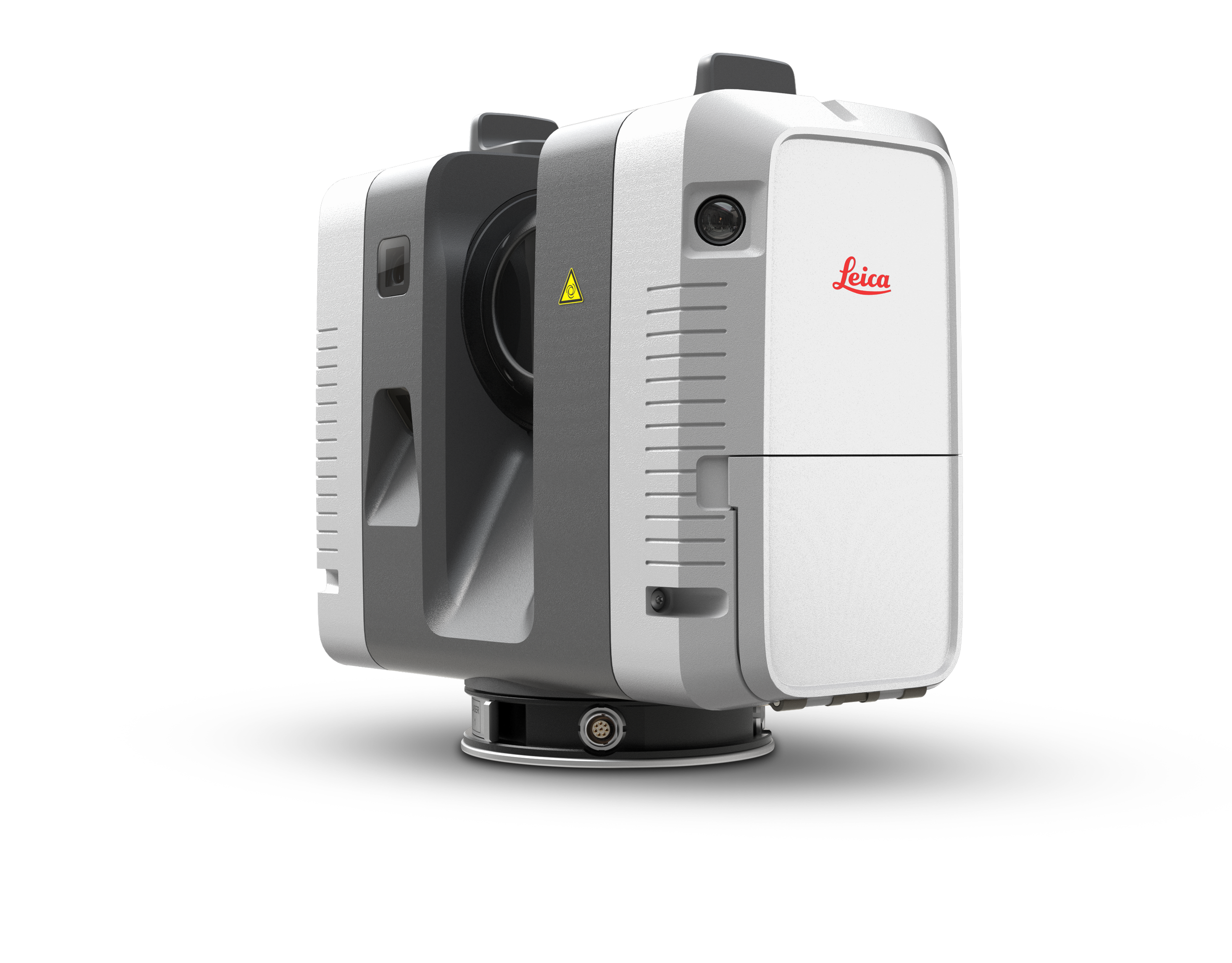
Our Equipment
Beyond data capture, Obsidian 3D employs a robust suite of Leica Geosystems software for seamless processing, modeling, and analysis. Our field operations are streamlined with Leica Field360, enabling real-time data visualization and quality checks directly on-site. Back in the office, Leica Register360 handles rapid and automated registration of point cloud data, ensuring highly accurate and cohesive datasets. For further processing, intelligent modeling, and advanced analytics, we utilize Leica Cyclone 3DR. This powerful software suite allows us to classify points into object categories (such as trees, buildings, street furniture, indoor environments, and pipes) and supports automated Scan-to-BIM workflows.
In addition to the core Leica suite, we leverage industry-standard design and modeling platforms, including Autodesk Software (Revit Architecture, Revit MEP, Navisworks, AutoCAD), SketchUp, Rhinoceros (RhinoCAD, Rhino 3D), and SolidWorks. This comprehensive technology stack, centered around the Leica RTC360 and its integrated software, ensures we deliver clean, accurate, and usable digital assets, from raw point clouds to intelligent BIM models, tailored precisely to your project's specific needs and ready for advanced applications like design validation and clash detection.
State-of-the-Art Equipment & Advanced Software
At Obsidian 3D, we utilize a best-in-class technology ecosystem to ensure the highest levels of accuracy, efficiency, and detail in our 3D mapping and point cloud services. Our cornerstone hardware is the Leica RTC360 3D Laser Scanner. This advanced, high-performance scanner is renowned for its rapid data capture capabilities, capturing up to 2 million points per second and performing automated in-field registration. It offers an angular accuracy of 18 arcseconds, a range accuracy of 1.0 mm+10 ppm, and a 3D point accuracy of 1.9 mm at 10 m, 2.9 mm at 20 m, and 5.3 mm at 40 m. This remarkable precision, combined with its speed, allows us to efficiently document complex environments, reducing on-site time and accelerating project timelines for our clients.